|
INTODUCTION TO THE STUDY AREA
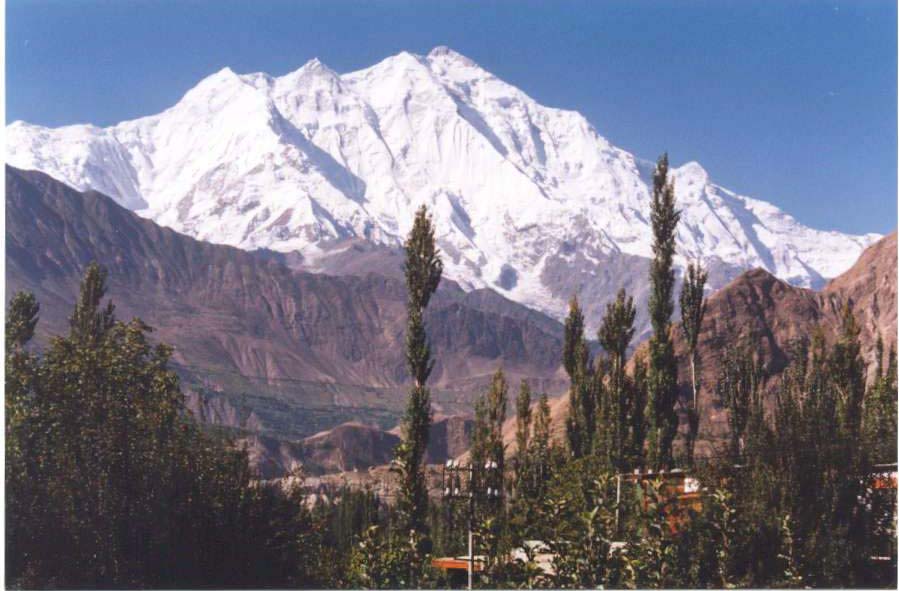
Hussaini Village is situated in Hunza valley, 145 km North of Gilgit and 45 km from Ali Abad in Central Hunza. Hunza River flows in to the east while the Karakoram Highway (KKH) passes to its west
1.7 LOCATION
Hussaini Village is situated on 740.50 and 00"east longitude to 360.50أƒآ¢أ¢â€ڑآ¬أ¢â€آ¢ and 00" north latitude at an altitude of 8000 feet (written on the signboard on the KKH) above sea level.
South of Hussaini is Gulmit (the headquarters of Gojal magistracy - tehsil), Ghulkin is to the southwest, while Passu is in the north with famous Batura glacier. Hussaini glacier is located to the west with famous Shisper peak, 7611 meter.
1.8 HISTORICAL BACKGROUND OF HUSSAINI VILLAGE
Hussaini is a small village of Gojal (Upper Hunza) in the Northern Areas of Pakistan. It is situated on the both banks of Hunza River. The old main village is on the western-bank and at the lateral moraine of Hussaini glacier and below Borith Lake. The newly irrigated land, called Zarabod, is on the left bank. The total population is 545 souls, living in 75 households.
There is no written history of the village. The history of the village can only be traced in the old folk stories and events, orally transferred from one generation to another. According to the known history, Hussaini has been settled twice. The people, who first settled here, were called Ghosanos. The origin of the Ghosano is not exactly known, however, some people say that these people were the descendents of the Warshighoom State, called Mehtarjaos (the princes but not legitimate to share in the governance)2.
Ghosanos had a very close working and family relation with the neighbouring village called Passu; almost all the ceremonies like marriage and festivals were celebrated together. The people from Passu were, and still, called Paswik and from Ghusani were called Ghusano. Once, Paswiks were invited in a party by Ghsanos, but due to the unknown causes, they quarreled with each other in the party. Most of Ghusanos were killed in the village. Some of them ran away downstream with the Hunza River. They were chased by Passuweks up-till Gilgit. Sirang Momad (Muhammad) and his son Sirang Qmut were Paswik heroes who followed the Ghusanos down to Gilgit. Raja of Gilgit arrested Sirang Momad and his son Sirang Qmut and gave shelter to Gusanos. The people from Ghosani left the village, and the ruler of Gilgit settled them some where around Gilgit.
Now the land of Hussaini was waiting for the new comers. A prince named Musofir ran away with his brother Majower from Ptukh Wakhan (presently in Afghanistan) due to tug of war in contest for throne of the state. Their elder brother was crown prince. He was unhappy with his brothers due to his position. The younger brothers were always scared of the elder brother because he could kill them to save his throne. One day both of the brothers left the sate and Majower escaped to Ishkomen valley (Presently in the Ghizer district of the Northern Areas), and Musofir came to Hussaini and settled thereأƒâ€ڑأ‚آ§.
ZARABOD
As it has been mentioned that Hussaini consists of two localities, the old settlement and the newly irrigated area called Zarabod. Zarabod is a Persian word: Zar means gold while abod means cultivated land. Thus, Zarabod formed by the combination of Zar and Abod. Why has it been named as Zarabod? The people of the village narrate that one of the princes of the former Hunza State, named as Bakhtawar (Baxtawor), was brought-up by a Sisunik (an inhabitant of Hussaini). Bakhtawar was the then Crown Prince who was killed by his brother Abdulla Khan. Therefore, the Hussaini people boycotted with Mir (ruler) of Hunza because of this killing. At that time, the people of Hussaini were strong enough in terms of fighting and wealth; and, therefore, the ruler of Hunza was scared of any revolt from these people. The Mir sent message through a messenger that he would accept all demands if these people would compromise with him. Now, the ball was in the Sisuniks court. They took two plates of gold with them to Mir and demanded for Zarabod. Mir excepted the gold and handed over Zarabod to the people of Hussaini. And, thus, Zarabod got its conception in this manner, and was cultivated.
BORITH
Borith is a hamlet and situated in the surroundings of the Borith Lake and to the northwest of Hussaini. The altitude of Borith is roughly 8500 feet above sea level. According to the people of Hussaini, the people of Hussaini used this land as winter grazing land. But these days, there are some disputes over this land between the peoples of Hussaini and Ghulkin.
According to the elders of Hussaini, a clan of Ghulkin requested Mir Jamal Khan, the last ruler of former Princely State of Hunza, to permit the aforementioned clan to cultivate the land. Mir did so along with an agreement that these people will grow the crops only and would not plant any tree and will not use the land for winter grazing, as this is the legitimate pastoral land of the Hussaini people. However, with the passage of time the people from Ghulkin started planting trees there to occupy the land. Anyhow, the winter grassing right still remains with the Hussaini peopley.
In contrast, the community from Ghulkin does argue on the other way round. This problem, however, needs a rational investigation to know about the disputes between the two neighbouring villages so that to have a consensus on their actual issue.
SELECTION OF STUDY AREA
Hussaini was selected for the study keeping in view the following points:
To carryout the socio- economic survey of this village, as no previous study of socio-economic and geographical nature existed about the area.
The village is easily accessible, as it is on the KKH and because of the road, tremendous changes have occurred in the area, that I wanted to study. < >
AIMS AND OBJECTIVES OF THE STUDY AREA
The study was conducted with the following objectives:
To find out the socio-economic and physical condition of the village;
To know the demographic pattern and education level of the study area;
To see the housing condition, pattern, amenities, and layout of the village;
. To find out the problems of the study area and give suitable suggestion for their solution;
To find out way and means for future development of the village.
METHODOLOGY
The following methodology was adopted for the study area:
The study is mainly based on the fieldwork and observations. However the secondary data has been obtained from different sources.
1.11.1 PRIMARY DATA
Field survey
Data about the different aspects of the village was collected in the field through questionnaires and interviews. In the field survey, I went door to door for collection the different kinds of data, as:
Housing pattern of the village
Housing amenities
Household size
Economic condition
Demographic pattern
Education
Needs and problems
< >
1.11.2 SECONDARY DATA
Secondary data was obtained from the following sources:
Population census reports of Gilgit district.
Meteorological office of Gilgit
The Aga Khan Rural Support Program (AKRSP) head-office Gilgit
The Aga Khan Education Service Pakistan (AKESP) Gilgit
Office Ismailia Local Council for Gulmit Gojal.
1.11.3 PROCESSING OF DATA
The data was tabulated, analysed and represented in form of cartographic/statistical diagrams and maps.
1.11.4 INTERPRETATION
The diagrams, graphs, maps and tables were interpreted in the light of physical and cultural factors.
Chapter-2
PHYSICAL SETTING
2.1 PHYSIOGRAPHY
Hussaini is located in the center of the Karakoram Range, surrounded by high mountains having the heights of more than 7000 meters. Most of the peaks, remain snow covered throughout the year. Shishper (7611 m) is the highest peak of the study area. The rock exposed in the area is mainly Slate i.e. metamorphic.
2.2 GLACIERS
There are two important glaciers in the study area: (a) Hussaini glacier, and (b) Zarabod glacier.
a) HUSSAINI GLACIER
The glacier is situated in the west of the village and moves from northeast to southwest towards KKH and Hunza River.
It is approximately 17.5 km long with a headwall at up to 5950 m between two peaks that rise to 7331 m and 7613 m. The glacier descends from 5500 m with a mean slop of 14.6%. Its terminus in 1980 was separated into two parts, a northern tongue and an irregular southern margin, which could be further sub-divided into two small lobes separated a melt water portal. It appears to have this general form since at least 1996. However, its heavily crevassed snout and numerous small caves testify to large scale melt water production. These melt water flows frequently change in volume and exit position. The changing pattern of debris production and redistribution on the steeply sloping out wash cone pose a major hazard to the Karakoram highway and a 200 m. section of road was actually destroyed by these means during August1980.
The main valley section of the glacier is enclosed between steep high moraines, the black debris-laden ice smothered by large quantities of superficial moraine. Ogives and rock fall crevasse pattern are well developed, and there are extremely steep ice falls towards the head. The twin lobes of the snout appear to have an extension in the ice topography for several km up the glacier, the two ice ridges being separated by the pronounced central depression.
The recent history of the glacier is poorly known since most visitors have merely confined themselves to discussing the difficulties of crossing the out wash spreads and only give crude estimates of the distance of the snout from the Hunza river. Although the precise pattern of movement is unknown, reliable records do exist which indicates that the snout position has fluctuated by 625 m during the period 1885-1980, with a notable advance between 1913 and 1925 and a further small advance between 1966 and 1978. This again repeats the general pattern observed for the Minapin and Hasanabad glacier, although the advance early in this century appears to lag by some ten to fifteen years. It is significant that the minor advance of the early 1970s appears on all three records. The movements, therefore, appear to be periodic but in this case there is no overall secular retreat. There has been no record of blocking of the Hunza river and no evidence either of massive retreat. Instead, the snout seems to have experienced limited oscillation around its present positionp.
According to this field survey, the distance between the snout and the KKH is 301 meters (990 feet)l. It is advancing for last many years. It can be predicted that if the same situation remains in future, it may be reach at KKH within between 10 to 15 years.
It is the only source of water supply for irrigation and also for drinking in summer season. The whole village is depending on this glacier, locally known as "Sisuni Yaz", but with an error or otherwise, this glacier is shown and advertised on the maps by Ghulkin glacier.
b) ZARABOD GLACIER
It is a small glacier between Zarabod and Khuramobod. Though it is not a glacier in geomorphic term rather is a depression called cirque. The stream originated from that glacier irrigates the land of Zarabod. This stream is shared between Zarabod (Hussaini) and Khuramabd (Passu). The stream water is shared by Zarabod, and Khuramobod on alternate day.
2.3 RIVER
The rivers of the valleys of Khunzhrav (Khunjarab), Misgar, Chipursan, and Shimshal which include the water of various famous glaciers Batura, Verzhrav, Khurdopin, Yazghel, Passu, Hussaini and Gulmit passing through Central Hunza and Nagar to Gilgit. Thus, this river is named as the Hunza River that flows from the north to the south.
TERRACES
a. HUSSAINI
Hussaini is located on a glacial landform e.g., lateral moraine, formed by Hussaini glacier. The moraine is exposed of huge boulders, gravel, pebbles, and sandy soil with a gentle slope.
Hussaini spreads upward from the bank of the Hunza River and reaches up to a considerable elevation along the lateral moraine of Hussaini glacier. In the south the snout of glacier and the glacial stream separates Hussaini from Ghulkin. In the northern part, the boundary of Hussaini, it ends at Rukhn kor with Passu.
According to the folklore, Hussaini was a big village of Gojal, but unfortunately Shimshal flood eroded it many times in early 1960s. It is said that the distance between Hussaini and Zarabod was very close, people used to throw stone to Zarabod by their left hands (about 60 meter), but now, according to this field survey the distance between these two villages (Hussaini & Zarabod) is 1 kilometer. Shimshal flood occurred periodically every twenty years, the last flood, which was very disastrous, came in 1960 and continued up-to 1963. This flood happened as a result of glacial hazard. Two glaciers merged Khurdopin and Yazghel with each other and blocked the stream of other glacier (Verzrav), which made a big dam and when it was opened, it eroded a large area of Passu, Hussaini, and Gulmit.
b. ZARABOD
Zarabod is located to the east of Hussaini at the eastern-bank of Hunza River. It is an alluvial fan, formed by Zarabod-Khuramobod stream. It also has a gentle slope. It starts from the eastern bank of Hunza River and goes up slowly and gradually and reaches at the foot of Zarabod glacier, which is locally called as أƒآ¢أ¢â€ڑآ¬أ…“Zworأƒآ¢أ¢â€ڑآ¬أ‚آ. The stream has naturally separated Zarabod from Khuramobod (Passu).
Chramn is the old settlement of Zarabod, where inhabitants of Hussaini live together in a local house. From this place they used to go their fields to work.
Zarabod has the following areas with different local names, Shah Khunzo, Qash Sar, Ben, Chramn, Put Dasht, Yinaghn, Hussneben, and Dasht.
Dasht means barren land, which is located to the north of Zarabod. The government magistracy (tehseel) and the Aga Khan Arbitration and Reconciliation board for the concerned region divided this barren land (Dasht) among the villagers in May 1998: this division of land was 23 kanal per households -numbering 72.
Zarabod has no jeep-able road, and it has connected with Hussaini through a suspension bridge (635 feet) called أƒآ¢أ¢â€ڑآ¬أ…“Duetأƒآ¢أ¢â€ڑآ¬أ‚آ, constructed in 1970. Both Zarabod and Suspension Bridge are too attractive in tourism perspective.
1.5 HOT SPRING
Nature has gifted a hot spring to this village, which springs out at the left bank of Hunza River. According to laboratory test, the water is drinkable. It has been using for bath, when the volume of water in Hunza River becomes less and the level down from the spring source in winter season, but the area is covered by river in summer.
CLIMATE
The average weather condition of a sizable area of the Earth's surface over a period of time is called climatet. Weather is the atmospheric conditions prevailing at a specific time over a short period, from hour to hour, or from day to day.
The climate in Hussaini can be divided into four seasons, i.e. winter, spring, summer, and autumn season.
2.6.1 WINTER SEASON
The winter is cold and chilly. It starts from 15th November and remains up to the end of March. From December up-to the end of February the temperature remains below 00 C. In winter Hussaini is sometimes covered with snow. Due to nearness of the glaciers, it has been noted, it receives much snowfall as compared to other neighbor villages. An annual average snowfall is 8 to 10 inches, but in January 2000, the snowfall was 14"(own survey in 2000), which is unusual for the last so many years. The snowfall is due to the western depression. Human activities become limited in this season. The people have to confine themselves to indoor activities: for example, cottage industry.
During these months the villagers also become busy in performing marriage ceremonies. The other activities for male are hunting, making Hunzai caps, Hunzai carpet called أƒآ¢أ¢â€ڑآ¬أ…“Plosأƒآ¢أ¢â€ڑآ¬أ‚آ. Female folk weave and spin. They make caps table-clothes and handkerchiefs. They also make gloves, Chogha (cloak), mufflers, socks and many other items.
2.6.2 SPRING SEASON
It starts from April to the end of May. A considerable amount of rain is obtained
in spring. All the fruit trees like apple, apricots, pears etc blossom in this season.
Agricultural activities are practiced in this season, e.g., wheat is sown, and
potatoes are also grown in this season. Almost all sort of plantation is carried out
during this season.
2.6.3 SUMMER SEASON
Three months, from June to August, is the summer season. These are the driest months of the year. The average temperature is low as compared to the plains of the country. These are also the busiest months for the people. All sort of agricultural activities, e.g., harvesting, and threshing of wheat, pasturing of cattle and drying process of apricots etc. is carried out in these months.
2.6.4 AUTUMN SEASON
From 1st September up-to 15th November is the autumn months. Rain is also
received this season. Fodder for cattle and firewood is stored.
< br>
2.7 SOIL
Soil in Hussaini is fertile sandy, and loamy on terraced fields. On the steep slopes, it is easily washed down by torrential rainfall, mass wasting and erosion, is the common geomorphic process in the area.
2.8 VEGETATION
Climatic conditions and soil types determine vegetation comprises forests, shrubs, and grasses. The climate is dry for forest. Soil formation on the hill slopes is a necessary condition for vegetation growth. But because of human practices in this area, the soil is being eroded rather than of soil development. There are two main types of forest, irrigated and un-irrigated or natural forest.
2.8.1 IRRIGATED PLANTED FOREST
This very important forest comprising of different species, e.g., apricot, walnut,
almonds, grapes, pear, peaches, apple, poplar etc. Poplar trees are mainly used as a timber and firewood. Mulberry and walnut trees are used for high quality furniture. In accordance with this survey in Hussaini, every household has 30 to 500 (mostly fruit) trees, because the villagers have common tradition of planting forest.
2.8.2 UN-IRRIGATED FOREST
This forest is found on the hill slopes in isolated patches. It supplies firewood to the villagers. Important species on the upper most reaches of the village are juniper, salix, epheda, with flexible and adopted to snow pressure. Berry fruits are also found.
Most upper reaches of the mountains have betula nana, salix, juniper, ephedra, vibe mum, loniera and ribber.
Borit-e- Ruy, Ishkor Sar, Ghaypar, Zarabod Roy and Batura are the main patches of these species. The main patches of natural forest and grazing points in Batura South are Jang-e-Kerch, Stugh Dhur, Baj Yarz and Nawgarch.
>
CHAPTER - 3
CULTURAL PATTERN
3.1 DEMOGRAPHY
Demography contains two Greek words, demo means أƒآ¢أ¢â€ڑآ¬أ…“peopleأƒآ¢أ¢â€ڑآ¬أ‚آ and graph means description: thus, demography means the study of the number of people in a certain area. According to the United Nations multilingual Demographic Dictionary أƒآ¢أ¢â€ڑآ¬أ…“demography is the scientific study of human population primarily with respect to their size, their structure and their development".
3.2 POPULATION GROWTH
Hussaini is one of the settled areas of Gojal in Hunza Valley. According to the census of 1981, the population inhabited by 310 individuals including 152 male and 158 female.
According to this field survey in August 2000 the total number of households were 75, comprising the total population of 545 souls. It consists of 278 male and 267 female, which shows an increase of 75.8 % and annual growth rate 3.9 % per year.
It is projected that because of high birth rate the population of Hussaini in 2010 will be 970.
Like other cities and villages of Pakistan, high growth rate in Hussaini is because of the following factors which are as under:
Natural Increase
Better Health Facilities
Early Marriages
High Fertility Rate
3.3 POPULATION DENSITY
Density is also called as man and land ratio. Density is the degree of compaction in a population. The degrees of proximity between people, the special balance of their social and economic assets.
According to 1981 census the density of population was 10 persons per acre, while in 2000 the population density has increased to 17 persons per acre.
br>
3.4 POPULATION COMPOSITION
Population composition is primarily identified in the term of its age and sex composition. The total respondent of Hussaini is composed of 545 persons, consisting of 51 % male and 49 % female.
3.4.1 SEX RATIO
Sex ratio can be defined as number of males divided by No of females of population is:
Sex Ratio = Number of Male x 100
Number of Female
Three factors influence the sex ratio viz preponderance of males births, migration and mortality of rates of sexes. In 1981 census the sex ratio was 96/100 and male female ratio was 49:51.
According to this field survey in 2000 the sex ratio is 104/100 and male female ratio is as the same 49:51.
3.4.2 AGE-WISE SEX RATIO
Age wise sex ratio can be defined as the ratio among persons at each age. This ratio is typically calculated for Hussaini Village.
3.4.3 CHIL-WOMAN RATIO
The ratio between children under 5 years of age and the woman of child-bearing age is called a child woman ratio
The child-women ratio of the study area is 345 children per 1000 women. It was found that 345 children were born to 1000 women or 1000 women can give birth to 345 children in a census year.
3.4.4 AGE STRUCTURE/POPULATION STRUCTURE
This is an statement of the number of people in a total population found in each age group. Population structure is the combination of children, adult and aged people. The children group is from 0-14 years, 15-64 years age group is called adults and 65 and above years age group are called aged.
Age structure reflects the demographic and socio-economic history of population. Age structure effects by the extent of mortality and fertility rates given in table no. 10.
3.4.5 DEPENDENCY RATIO
Dependency ratio is defined as the number of person in a population who are not economically active for every 100 economically active persons in that area. The dependency ratio is useful in economic studies.
According to this field survey the dependency ratio is 142 % in Hussaini. It shows that there are 142 dependents per 100 earning members. They are not active economically, so they depend upon other Persons.
3.5 MARITAL STATUS
Marital status of population refers to proportion of single, married and divorced persons.
The data about the marital status in Hussaini, and it was found out that in 1999, both sexes 75% are married, while 20 % (above 20 years) are un-married and 5 % is belonging to widow group.
3.6 HOUSEHOLD SIZE
A household can be defined as أƒآ¢أ¢â€ڑآ¬أ…“A single person living and eating alone or a group of people living and eating together. In 1981 the total household were 47 and household size were 6.5.
In this field survey the total 75 households that have 545 populations, in which 278 male and 267 females and average size of persons per household is 7.26.
The largest household in the area has 14 members while smallest household has 3 members.
3.7 TYPES OF FAMILY
According to this field survey the average size of family is 7 persons per household. While the density of room is 4 Per room.
There were two types of families living in study area.
Nucleated family and joint family.
3.7.a NUCLEAR FAMILY
Single family includes husband, wife and unmarried children. According to this field survey 73 % of the total family is of this type of family system.
3.7.b JOINT FAMILY
In this type husband, wife, and their married children are living together. The remaining 27 % of the total family lie in this category.
< >
3.8 CLANS OF HUSSAINI
Four clan settlers inhabited in Hussaini namely:
Shool Ktor
Murgh Ktor
Yughi Ktor
Fidu Ktor
As there is no written history of Hunza, Nager and Gilgit but the major source of information on the history of the area is the genealogical account of the ruling families of Hunza, Nager and Gilgit, complied in 1930 by Sir Muhammad Nazim Khan, Mir of Hunza.
It is said that Musofir had come to Hussaini from Wakhan (Afghanistan) and settled here, so the first immigrant was Musofir, the epical ancestor. After Musofir, Ali Mohammad also came from Wakhan and settled here, Akhon Ktor, is called behind the name of their grandfather.
Fata Ali who has come from neighbouring village Passu, actually they are Quli (Sakhi) Ktor but in Hussaini they are called أƒآ¢أ¢â€ڑآ¬أ…“Fido Ktorأƒآ¢أ¢â€ڑآ¬أ‚آ, behind the name of their grandfather. Yoghi Ktor, and Murgh Ktor are the sub-clans of Musofir.
< >
3.9 EDUCATION
Hussaini like other Ismaili towns and villages of Hunza enjoys a high literacy in the Gilgit District. The first school was established in Upper Hunza was in Gulmit in 1946, on the occasion of the Aga Khan III diamond jubilee ceremony. These schools are named as D. J. Schools. There are two primary schools in Hussaini village. For higher education students go to near by village Gulmit and down country.
Most of parents cannot afford to send their children to down country for higher education, but still a number of boys and girls are studying in Gilgit, Peshawar, Lahore, and Karachi.
SCHOOLS IN HUSSAINI
There are two primary schools working in Hussaini, one from Govt. and another from AKESP.
1. Government Primary school was established in Hussaini in 1971. Due to Urdu medium most of parents admitted their children in English medium schools, so now there are only 17 students in different classes.
2. The Aga Khan Diamond Jubilee School was first school established in Hussaini in 1962. It is an English medium school for boys and girls. There are 80 Students including 37 male, and 53 Female students.
< br>
3.10 TRADITIONS AND COSTUMES
LANGUAGE
Wahki is the native language of Hussaini. It belongs to the Pamiri branch of eastern Iranian languages. They migrated to this part of Hunza from Wakhan, Pamir, and Badakhshan before the end of 18th century. Hunza wakhi does not differ widely from Tajikistan, Afghanistan and Chinese Wakhi. It is a bit more archaic, specially in vocabulary.
3.10.1 SOCIAL CEREMONIES
Social ceremonies are essential part of human societies. These ceremonies are related to human life cycle comprising of birth, Circumcision, Marriage and death. Other social event are also celebrated collectively, details of social ceremonies of Hussaini are given.
< >
a) BIRTH
Being "patriarchal" and "matrilineal" society the birth of baby boy is marked with gun fire in the air which is actually a nosegay conveyed to all the neighbouring houses, friends and close relative who are looking forward to this occasion although the gun is fired by men, but the women of the neighboring houses, and close relatives pay a visit to the parent's house of the new born, presenting gifts in cash and in kind to the new baron. Sometimes services are also rendered for the new boron's parents help in conduction their agricultural works. Especially women coming from the neighborhood or close relatives of the new boron's parents extend their full cooperation to do the chores.
When the baby girl is born the event is taken up quietly as this is also an occasion of happiness but this happiness has to be concealed. Traditionally parents think no need to make announcement with gunfire, but are no restriction on the gift services.
The maternal grandparents of the newborn also visit then with expensive gifts. The hosts usually slaughter a goat or sheep to serve the visiting guests with food.
b) MARRIAGE
Marriage is another important event in the life cycle and also in the village social structure and activities. It is celebrated with great pomp and show. The parents in consent select the eligible boy or girl for the daughter or son with close relatives. At the time of engagement gifts are given to the bride. These gifts are in the form of cloths, pair of shoes, socks and a few woollies like sweater and shawl. These gifts are used at special occasions in the duration between engagement and marriage. Many of the gifts are left for the marriage. The Nikah ceremony takes place in the Jamatkhana where consent of both the parties is sought and paper sighed. For Meheer an average of Rs 10000 is decided with the consent of both the families also after the assessment of financial conditions of the bride groom, which is seldom payable at the time of Nikah and marriage.
Usually the people prepare their sons to get married in their early twenties; the girls get married in their teen age, maximum at 17-19.
< br>
c) FUNERAL RITES
When someone dies, the body is given the bath, and body is wrapped in white cloth (kafan). The near relatives, friends recite the Holy Quran for eternal peace of soul of the deceased. Before the burial the dead body is kept for all the mourners to look at face of the deceased. All attending the funeral say the Namaz-janaza and after the burial takes place. Usually no food is cooked in the deceased's house for some days. The relatives, friends and neighbors have the duty to provide cooked food to the bereaved family. On the third food is cooked in large quantity to be served to the villagers. There is a tradition called "Chiragh Roshan" where an oil lamp made of wool offered in to the oil (sesame or apricot oil) is placed in a Chiroughdon. The khalifa recites some verses of Quran and Chiroughnoma of Pir Nasir Khusrow and Ismaili Dayiee of 10th century. On the seventh day food (Molida) is cooked by the bereaved family in large quantity to be served to the villagers. On the fourth day again the villagers are served with food and the Khalifa recite Quran for the forgiveness of the soul of the deceased.
3.10.2 AGRICULTURAL CEREMONIES
KITZIT: SPRING CELEBRATION FESTIVAL
KITZIT is on e of the Wakhi ceremony celebrated in the month of February to welcome the spring season. On the day o f the celebration every household prepares variety of traditional food, gather at one place, where all the people pray for unity and blessings, betterment of all humans, pool all the prepared food and eat together.
KITZIT marks the end of wordlessness, lazy hibernating winter and gives new working life and regularize the people for new season to work with greater zeal in the field and outside homes. The farmers prepare their fields for the cultivation and also spread manure. There is an old custom of sprinkling flour over the wall and pillars of the houses. Kitzit was also a day for the youngsters to play Toksuri (a traditional base ball type game)
TAGUM: SEED SOWING FESTIVAL
Usually this ceremony takes place in the first week of March, which last for two days. On the first day the villagers gather at one place carrying the dish of Khamali or the bread of Semn (local dish made of wheat flour).
The next day again people gather at the same place with their own Semns (this day the Semn is cooked like pudding or like halva). Then a pair of oxen and the Shahgunputhuk (a person representative of a family, member of which are traditionally symbol of agriculture) is brought. The Khalifa prays for better crops, unity, and success. After prayer the Shahgunputhuk sows the seeds in the field, and then all the villagers start sowing the seeds (symbolically) in their own fields. Taugm marks the day of sowing after this rite , cultivation starts in the village followed by Jugun (a traditional polo played without horses), which is played by the villagers.
e) CHINAR: HARVESTING FESTIVAL
It is celebrated in the month of July, usually on 10th or 12th, when barley crops is ready to be harvested, the cutting of barley is a men's affair so they go out in the fields carrying Khamali, the bread, ghee, the migraine and Spandur, tiny herb grain the smoke of which is used as air freshener. They all gather by the field. A small rite takes place before the start of the crop cutting which is that the oldest man puts Spander on fire so smoke comes out and he cuts some barley and gives it to the men who bring them to their homes where the house wife cooks a delicious dish and put the barley grain in it. When the food is cooked then every man brings the food to a decided place of summoning, where they all take the food, and pray to God for good yield, after this the harvesting takes place.
3.10.3 RELIGIOUS INFRASTRUCTURE
People of Hussaini village belong to the Shia Imami Ismailia tradition of Islam. There is one Jamatkhana with one religious center. The Jamatkhana has a leader called "Mukhi" and "Kamaria" to assist him. Village has a khalifa, who is responsible to religious part of birth, death, and marriage ceremonies. Within the Jamatkhana there are different committees to manage the system. These committees comprise of volunteers from the village. There are Boys Scouts, Girls Guides, Shoes Company, Water Company, Light Company etc. All the committees are performing their duties under the supervision of Mukhi. Mukhi works under supervision of Local Council, Regional Council, national council and International Council. The office f the International Council is in Geneva and the National Council in Karachi.
RELIGIOUS CEREMONIES
EID-UL-FITER
On the day of Eid, all the villagers gather in Jamatkhana's ground and say their prayer. This is a very happy occasion for all of them. They show their happiness by embracing with and giving to congratulation to one another. Special foods and dishes are prepared. They visit one another's house. There are different recreational activities for children and they enjoy best of their time.
b. EID-UL-AZHA
There are also special preparations to celebrate this Eid. People are slaughtering animals. They wear new send meat/mutton to their neighbors and relatives. Sacrificing of animals is performed after saying prayer.
3.10.4 POLITICAL INFRASTRUCTURE
The Lumbardar is the head of the village in this area. He enjoys a great political power. There is a member of Union Council. A member of Community Arbitration Board in the village is responsible for conflict resolution. This Board is comprises of a president, secretary and members. Whenever a conflict arises, the sufferer tenders an application to the secretary/president of the board.
President and secretary issue a circular calling all members of the board in the office (Gulmit) on fixed date. This meeting in addition to Board members may have some elders of the village for conflict resolution. If any of the disputant ignores the decision of the board, he may tender he application in the Tehsil or Police Station. Normally Tehsil/Police Station first instructs both disputant parties to once again consult Arbitration Board. If the case is an outsider or with governmental organization, the Numberdar/Members Union Council/Member Arbitration Board are dealing with the case jointly.
<
CHAPTER - 4
SETTLEMENT PATTREN
4.1 SETTLEMENTS
أƒآ¢أ¢â€ڑآ¬أ…“A dwelling unit is called settlementأƒآ¢أ¢â€ڑآ¬أ‚آ. Hussaini developed about five hundred years ago. First of all Musofir immigrated to this area from Wakhan (Afghanistan) and settled here.
SETTLEMENT LOCATION AND DISTRIBUTION
People have been very particular about the location of their dwellings and giving importance to the sitting and situation of houses.
Old time settlements were located in the center of the village and agriculture area surrounded it, but in the past 30-50 years many new settlements have been constructed in different places of agricultural land.
The settlement is of dispersed type because the villagers site their houses on their individual fields. The area also remained safe and secure, and therefore the people did not find it necessary to cluster their houses together in selected sites. Thus the houses are scattered throughout the village from one end to the other end.
4.3 SETTLEMENT PATTERN
Settlement pattern concerns with the character of the settlement that is weather they are clustered or dispersed pattern.
In the study area there are three types of settlement patterns.
Clustered, linear settlement pattern, and dispersed settlement pattern
CLUSTERED PATTERN
In clustered pattern all the houses are grouped and attached to one another. In the study area, clustered pattern has developed at four different places.
LINEAR SETTLEMENT PATTERN
Settlement constructed in a line along the road, come in linear settlement pattern. In the study area, eight houses were constructed in linear type, along the un-metalled road.
4.3.3 DISPERSED SETTLEMENT PATTERN
These types of pattern are found to the north and south of the village.
4.4 GRAVEYARD
There is a particular place reserved for graveyard, located in the north of the village on a high land along the KKH.
4.5 DESIGN OF HOUSE
The important house type of the village is Wakhi house type. The Wakhi house is the combination of all human activities in one open connected space. The whole structure is erected on five central pillars to support the roof. The fireplace is in the middle of the floor. The different functions of houses are located around the central fireplace (buxari)(gafe). The house has a lantern ceiling type. The roofs have chimney holes (ricen) of about nine inches in diameter, which is the only way to let in light. During rain or snow a lid being placed over it, closes the ventilator. The roof is completely flat from end to end.
The inside of the house is divided into different sections to be used for different purpose e-g. siting (nikard), sleeping (razh), store (ganz) etc. The villagers have also a separate portion for guests called أƒآ¢أ¢â€ڑآ¬أ…“Bangulaأƒآ¢أ¢â€ڑآ¬أ‚آ. This mostly comprise two to three rooms for guests.
Next to the entrance on the left side we find the room or storeroom. The entrance Kunj comprises the lowest level of the house as well as the place, which is called Yorch, where all footwear has to be left on the right and the left side two elevated platforms to be found called Razh, which are utilized for sitting during the day and for sleeping at night. When one enters the house the right platform is assigned to men and the left one to women. Behind central fireplace there is the cooking platforms called Dildung. This is the special sphere for the housewife for long houses. She is occupied with preparation of food for the whole family, the preparation and distribution of food is done here and she can survey the whole scene. Behind the cooking platform there is Chikish and store, which is reserved for housewife. There all utensils are displayed in a cupboard Trak and edible are stored in special containers of the store. Guests are asked to rest against the pillars supporting the flat roof and to sit in the corner of their respective platform (Dildong Ben), which is the place closet to fire in order to importance. The animal portion called Ghel is built at some distance from the house. It consists of three to four rooms. There is also a room for storage of fodder called wueshdoon.
CHAPTER - 5
HOUSING CONDITION
< >
5.1 HOUSES ACCORDING TO AGE
Age of the house reflects when was a settlement established. It was found out that the different houses were constructed because of various reasons. Although the old settlements of Hussaini village is eroded by Shimshal flood in early 1960s, but some houses are still there, an age of more than three hundred years old.
The recent houses constructed in the past 10 years includes 25 % of the total houses, showing the trend of new buildings it means there is high trend of new buildings. The second important category are of those houses, whose ages are above 50 years and above, those constitute 22 % of the total houses, it means there are oldest buildings mostly people live here by birth.
There are 25 % of the total houses, these houses were built of following reasons due to:
One of the reason to be the family extension also because of the higher
families have broken into small units, who keeping in view their desire for separate living, have launched new houses.
The income of different families has augmented in the recent years. The flow
of money has encouraged a desire in many of them to built houses with considerable modern amenities.
Many older houses were demolished and the present ones have been raised on
Their foundation, this reflecting a trend to live in better houses.
5.2 STRUCTURE OF HOUSES/HOUSING PATTERN ACCORDING TO BUILDING MATERIAL
Houses are classified on the basis of their material. According to their structure, the houses of the study area can be classified into two types of houses, kacha, and pacca.
5.2.1 KATCHA HOUSES
Kacha houses are those, which are constructed from mud, stone and wooden beams. Mostly mud is used in construction of walls, wooden beams and pillars and hay is used for roofing. Materials used for construction of above-mentioned building are stones, mud, hay, and wood. Wood and hay is provided locally. Poplar trees are grown abundantly in the area, which are used for construction purposes.
In the study area mostly, roof of the katcha houses are constructed using wood, hay and mud. The percentage of katcha house in the study area is 48 %.
PACCA HOUSES
Pacca houses are constructed using stones, bricks, and cement, and the roof is constructed using wood. In the study area 24 % are pacca. The percentage of pacca houses is less than katcha houses.
>
5.3 NEW TREND IN CONSTRUCTION OF HOUSES
In the past the houses were built in a manner that the houses and the animals rooms were attached together, but at present they are built separately.
The houses were kacha till some year's back, while Pacca houses are constructed at present materials like cement, tile etc. are abundantly used in construction of houses. The old trend seems to have finished and the people very keenly adopt modern ways.
In Hussaini 98% of the room walls are constructed of stones, while the bricks, is used only in 2% of the houses.
5.4 TYPE OF HOUSES
It is further divided into single and double storey.
5.4.1 SINGLE STORY HOUSES
In Hussaini 47% houses are single storey houses in the region while the new trend does dot encourage the old design houses in the region.
5.4.2 DOUBLE STORY HOUSES (BILDI + MARA)
Although, there is no concept of double storey houses in the village, but in traditional houses, the upper portion store (Mara) is used for storage of dry fruits and other needs of life. While another portion (Bildi) is used for sleeping in summer season, and also use for the prevention of dry fruits like dry apricot etc. in rainy days.
In the study area 53 % houses are double storey types (house including Mara and Bildi). These are mostly kacha houses.
>
5.5 LIVING ROOMS
The traditional living rooms (houses) are used for multi purposes i.e sleeping, dining, sitting, cooking food, and storage of foodstuffs.
< r>
The field study show that 65 % houses have two or more living rooms per household, while 35 % houses having one living room or single traditional open house. Average number of living room is 2 while the density of living room is 4.06 per house.
5.6 BATHROOM AND TOILETS
According to this field survey 44 % houses have toilet system and 23 % have attached bathes, mostly in modern houses.
5.7 GUEST ROOMS
In the study area guestroom comprises 40 % of the total household. It also seems that some modern houses have an annexed guestroom with traditional house and attached bathroom for their personal guests.
5.8 ANIMAL SHED
Animal shed (Ghel) plays a vital role in their lives. Since keeping of cattle is common, therefore they need space for their sheds. They are found in different shapes. In most of the cases, a number of small rooms are found in the corner of the cultivable fields.
< >
5.9 HOUSING FACILITIES / UTILITIES
Almost all the houses in Hussaini have the facilities of electricity and fuel.
Water Supply, Electricity, Fuel Consumption
5.9.1 WATER SUPPLY
Drinking water is obtained from glacier and piped water only in summer season, because the glacier water freezes in winter for three months. Therefore the villagers meets their need of water from the Hunza River. It is one of the main problems of the village.
5.9.2 FUEL CONSUMPTION
There are five categories of fuel used for cooking and heating purposes. The important source of fuel is as follows:
br>
5.9.2.a FIRE WOOD
It is extensively used as a source of energy in Hussaini. Almost al the villagers have there own-planted forests called "Zakh" thorn is obtained from three different sources:
That which is brought from natural vegetation surrounded the village. It is still used by those, who are financially poor.
1. That which is obtained from the planted forests.
2. That which is purchased from outside, this trend is increasing day by day, with the improved transportation system. However only economically sound people can afford to purchase the wood from market.
5.9.2.b ELECTRIC HEATER
Electric heaters are used for heating and cooking purpose throughout the year. Economically sound people mostly use it, but it's also consumed by the low income people too.
5.9.2.c GAS CYLINDER
Gas cylinder is used as a source of energy. Gas cylinder is brought from Gilgit and China.
< >
5.9.2.d COAL
In winter because of intense cold, coal is an important source of energy. It is used for heating purpose and it is also brought from China.
SOURCE OF LIGHT
Electricity is available in the village. Every house is facilitated with electricity in Hussaini, but in Zarabod there is no electricity available. Due to the lack of infrastructure like road, bridge water supply, and electricity, Zarabod is a seasonal settlement for the inhabitants of Hussaini.
The electricity is supplied by Khyber hydel Power station that is far away from Hussaini. This station has a capacity of 4oo-k.w. and for Hussaini it supplies 50 k.w. electricity.
5.11 DOMESTIC GADGETS
Different domestic gadgets reflect the economic situation of a study area. In the study area nine types of domestic gadgets are found in which radio, iron oven etc. are common.
In Hussaini 83 % household have radio, 71 % electric iron, while 96 % of the household have sewing machine. As most of ladies sew for themselves. T. V. and V.C.R. is watched in 5 % household, and Dish is found in 3 % of the total household.
CHAPTER - 6
AGRICULTURE
6.1 INTRODUCTION
Agriculture is one of the important means of livelihood and occupation of the people of the village. Which contributes the 70% of the village income employing more than 65% of laborforce.
The village has a plain area, while soil and temperature are suitable for agricultural practices with availability of water in the village.
6.2 SPECIAL ASPECT OF AGRICULTURE
a. OWNERSHIP
Hussaini like the rest of the Northern Areas is the home of small farmers distinguishing them from rural areas of Pakistan in peasantry. Almost all the farmers are owner cultivators. Overwhelming majority of households comprise small land possessing about two acres of land each.
b. SINGLE CROPPING
Mostly one cropping season is found in the region. Double crops do not mature due to low temperature. In some year ahead double cropping may be possible.
Nearly every household is engaged in agriculture while some being wholly dependent on supplement, their household income is other means mainly non-farming work.
c. MANURING
Organic manure and chemical fertilizer are used in general. The farmers keep a limited number of animals for organic manure. The organic manure is mixed with soil before cultivation of crops. This is not available to them in sufficient quantity. Urea is mostly used when crops have started to grow, but it is not available to them in sufficient quantity.
6.3 AGRICULTURAL METHOD
In agriculture ten years before old techniques of ploughing were practised with wooden plough and a pair of bullocks. But now tractors are used for this purpose. These are almost two tractors in Hussaini. The crude method of harvesting the crops is still in practice. The use of sickle is being practiced most commonly. In the past animals were used for thrashing, but now a days thrashers is used for thrashing of wheat and barley. There are two thrashers belonging to the villagers themselves, while the rest comes from out side of the village.
6.4 IRRIGATION SYSTEM
Nature has gifted Hussaini by two important glaciers namely Hussaini and Zarabod. In Hussaini for irrigation purposes, people have to work hard daily on glacier, otherwise they can't get water for irrigation and drinking too.
There are five channels, taken out from the glacier. These channels are repaired and cleaned once in a year in the spring season by the villagers. Following are the channels of irrigation in Hussaini.
In local language "Yishoon" is the amount of water sufficient to irrigate a certain piece of land. The volume of water in Hussaini depends on the duty of people. The farmers also have to face the shortage of water when the temperature is low and glaciers have not melted.
On the other side Zarabod has a unique irrigation system, four or five farmers (Diqunishth) are responsible to irrigate the all sort of crops, such as wheat, potato and fodder crops. During their tenure, nobody has allowed to irrigate their own lands. Every householder has to perform his duty there every ten to fifteen years later. They perform their duty for four months tenure (May - September). The water originated by Zarabod glacier is shared by two villages Zarabod and Khuramabad (Passu). The stream irrigates the lands on alternate days. The stream water is not sufficient for the irrigation of these two villages. An area larger than the irrigated land of Zarabod is barren due to shortage of water.
6.5 CROPS
6.5.a WHEAT
Wheat has remained the staple crop in Hussaini for long time, but now-a-days potato has taken its position. In Zarabod it is also the main crop. It accounts only 10% of the total cropped area in Hussaini. When potato was introduced in the area, the cultivation of wheat is decreasing gradually. Wheat prefers mild temperature and 2" of rainfall. At the time of ripening and harvesting the temperature should be above 570 F. Such type of condition prevails in the area. In Hussaini it is sown in April and is harvested in August.
6.5.b BARLEY
Barley is also cultivated in this area. Its yield is low as compared to wheat. It accounts 35 maund per acre. Now a day it is used as a fodder crop.
6.5.c MAIZE
It is kharif crop in this area. It is sown in May and harvested in October. Maize is primarily a fodder crop.
6.6 FRUITS
Most important fruits grown in this area are apple, apricot, pear, grapes etc. but the production is consumed locally due to inaccessibility to the large market area.
<
< 6.7 VEGETABLES
Different varieties of vegetable are grown in this village. They are mostly grown in kitchen gardens and consumed locally due to inaccessibility to large market areas of down country. Some vegetables are dried for winter season. Important vegetables are tomato, potato, turnip, peas, cabbage, carrot, radish, onion, and chili.
6.7.a POTATO
Potato is the most important and single cash crop of Hussaini and the entire Hunza Valley. The Aga Khan Rural Support Program (AKRSP) encourages the cultivation of potato in Hunza. Due to this encouragement normally each household has devoted most of their land for potato cultivation. Because of its continuous cultivation for many years, its production is decreasing annually. In potato production and quality Hussaini is one of the important village in Hunza Valley.
6.8 HORTICULTURE
This is also an important source of income and includes fruit growing and vegetable production. The environmental factors like soil, climate and water all have contributed their best for making the area suitable for horticulture. Several kinds of fruit trees are planted here. Most important fruit trees grown in the area are apples, apricot, pears, mulberry, etc. their acreage is increasing every year.
In Hussaini every household has his own small or large orchard, previously the farmers did not give much attention to scientific aspects of planting trees. But now a days these orchards are being developed under the guidance of agricultural experts and more than hundreds have been developed on scientific basis. Moreover considerable new area is brought under orchards every year. In view of its grains, obtained from horticulture, the farmers are now giving preference to horticulture as compared to food crops. It is hoped that in future forty to forty five percent of cultivable land will under the fruit trees. In short it has a bright future.
It is worth mentioning that AKRSP has played an important role to promote interest among the farmers for development of horticulture in the region.
6.8.1 PROBLEMS OF HORTICULTURE
Lack of marketing facilities is adversely effecting the tempo of the development.
It is essential that the proper step for marketing facilities should be taken so that the farmers can get real benefit of their labour.
6.9 AGRICULTURE EXTENSION PROGRAM
Agriculture extension program is started on the basis of following points:
To prevent the crops from damages.
To increase the production of crops.
To develop horticulture.
To develop the cultivation of vegetables.
The following steps were taken to improve the above mentioned points.
6.9.1 PROVISION OF SPRAYS
The crops and orchards are sprayed with insecticides to prevent them from all kinds of insects and diseases. Some are sprayed free of cost to make the people aware of its significance.
6.9.2 SPRAY PUMP AT CONCESSION RATE
In the village spray pump full of drugs have been given to them at concession rate they could themselves prevent their crops from damages.
PROVISION OF DIFFERENT KINDS OF WHEAT
Different kinds of wheat were sown on experimental basis for the improvement of per acre yields. The farmers liked the idea and they started growing these new kinds of wheat.
6.9.4 TWO CROPS
Two crops in a year can be grown in half the area of Hussaini, while in other half one crop is grown. After the harvesting of wheat maize and millet can be cultivated. Through this method production has doubled since 1982.
6.9.5 TRAINING
Since AKRSP has become functional in the area, it has trained the people in this field. These experts teach the members of their respective societies that how to graft, trim and spray the plants. The villagers pay their fees per hour for spray and grafting. So that in this way the farmers could become independent of government or some body else's help.
Moreover in the meeting of AKRSP the farmers are interested how to improve the production. AKRSP calls the President and General Manager from each society in three months to the conference to know their problems and then helping them in solving their problems.
6.9.6 PROVISION OF VEGETABLE SEEDS
Similarly vegetable seeds were also distributed among the farmers, so they could grow them and observed the differences between the production of old and the new varieties. Turnip and pears are particularly cultivated for commercial scale. Other vegetables, like bean, radish, and cabbage, also been planted to grow them on a large scale. New kinds of seeds were also introduced.
6.9.7 PROVISION OF NEW KINDS OF APPLES
For improving the quantity of apples new kinds of apples have been imported from France by AKRSP's Agricultural Department. This department provides loans to member of the society for a joint nursery. The department also provides plants for individual gardens.
The engrafted trees of farmers are grafted by new in the supervision of the departments. For grafting good pieces are given by the department.
6.9.8 PROVISION OF OTHER PLANTS
The department (AKRSP) buys plants from government nursery and provides these plants to the societies on the same price. These plants include cherry, almond, walnut etc.
The department has established a nursery on one-acre land for women society in Hussaini named "Hussaini Women Tanzeem". Annually thousands of plants are distributed from these nurseries.
6.9.9 PREVENTION OF CROPS FROM DISEASES AND INSECTS
For the prevention of crops from the disease and insects AKRSP have make arrangements for spray on experimental basis. Beside it also tries to control plant disease by other measures. Now a day fruits like apples, pears and dried fruit are exported in cities down country. This department is also working for improvement of fodder crops. The department also distributing magazines and booklets, so those farmers could know how to look after their crops. They are introduced how to produce more crops with the use of fertilizers, prevention of disease etc.
6.10 LIVESTOCK
Livestock are very important in an agricultural community and considered as backbone of economy. In Hussaini beside sheep and goats, cows and poultry are also reached for dairy products and supply of meat.
Different animals are kept for different purposes. Mechanization is still not being common. Cattle provide drought power to the farmers. The bulk of domestic needs of meat are met by local supply. Sheep and goats provide milk and meat; their skin is also used for different purposes. The carpet that is made from hairs of goats is called "Plos" from the wool is called " Yijin". These are used for only domestic purposes.
In Hussaini goats and sheep are taken to the summer pastures from May to September. Women do not hesitate to go to summer pastures probably because the workload up in the pastures is less than their normal workload and there is also a feeling in the Fairy Mountains. Women's work is limited to look after the cattle and cooking.
On high pastures butter is produced from milk and preserved for their marriage ceremony and other uses. Qurut (cheese) is produced by boiling milk and dried in the open air out of the access of animals. The milk has to boil for several hours to produced Qurut and firewood has to collect from distant places, which are felled down by sliding or damaged, by snow avalanches. Bu now a day deforestation is also started in these areas.
As compared to the past the number of cattle is decreasing with the passage of time. This is because the inhabitants how send their children to school. Thus there is no one to look after the cattle. In average a villager keep five to eight cows and bullocks and ten to twenty sheep, and goats. There is no program for breeding of animals. All the animals are local breeds they are less profitable.
Although a majority of farmers still view with the tending of livestock as a way of life and a pattern of subsistence several families seem to be on their way out of herding. This decline of livestock tending has already has some negative consequences on the diet and health of families. Moreover unlike the past practice of making a healthy diet milk obtained from the cattle is now merely consumed for tea which is easy to make as compare to soup which takes quite a few hours to prepare. The availability of made of woolen cloths has reduced the importance of local wool and in turn of goats and sheep.
6.11 PASTURES IN HUSSAINI
In Hussaini good grazing grounds on high pastures are available to the people. These pastures are not restricted for any tribes. All the Sesonik have the right to use all kind of resources available on the pastures. They can build houses on the pastures. They can use these pastures according to their access. These pastures are utilized from May to September. In winter these are not habitable due to heavy snowfall. In winter grazing is only possible in the near to settlements.
A number of pastures of Hussaini are given below are used by the villagers.
Mulungin, Pasth Garben, Wuch Garben, Kirgaswashk, Wudmur, Maidun.
There are many grazing places around the village. These grazing grounds are utilized in autumn, winter and spring season from 15th September to 25th May.
The list of grazing areas around the village are given below:
6.11.1 BATURA PASTURES
It is a U shape valley. It is alignment is from northwest to southeast, situated on the northwest of the KKH and Passu village. Batura pastures are located on the both sides of Batura Glacier, in the south lies the area of Hussaini and in the north is Passu. The people of Hussaini have the right to graze forty oxen in the pastures of Passu. These are seasonal settlements for four months from May to September.
6.11.i BATURA GLACIER
Batura Glacier, which is 57 km long, and a number of peaks more than 7,000 meters high flaking the glacier, e.g. Batura I (7785 m), Passu peak (7678 m) are the heighest peaks of the Batura Range.
The Batura glacier terminus in both well known and of considerable local significance because it descends so close to the Hunza River. Historically it is known to have occupied a position either close to, or across, the Hunza River and may even have created a temporary dam in the past, with resultant flood damage to the villages of Passu and Hussaini. Since the 1940's, however, the glacier has retreated quite rapidly until 1966. Since that time it has again tended to advance steadily and is at present 700 m from the Hunza River(. This later advance caused a considerable damage to the Karakoram Highway and led to the intensive study carried out by the Chinese investigation group. They concluded from ice flux, ablation and velocity studies, that the glacier should stop advancing during the period 1997 - 1997, with a predicted further advance of 180 m - 240 m before that time, taking to within 300 m of the Highway. Starting from the 1990's they predict that the glacier will once again decline and this will last for at least 20 to 30 years.
It is notable that the Batura, which is a longitudinal valley glacier of great size and complexity, does not having a similar temporal fashion to the much smaller and relatively simple transverse glaciers hitherto described. The phase of rapid advance in the early part of this century displayed by those glaciers did not occur on the Batura, which remained virtually stationary from 1885 to the 1940's. However, the retreat which occurred in the 1950's and 1960's and the subsequent advance (both real and predicted) perhaps shows a pattern which is related to advanced to larger scale changes in the regional environment.
6.11.ii MASS WASTING IN BATURA (SOUTH)
Mass wasting is the common geomorphic phenomena in the Batura southern pastures. The following mass wasting types are common in the area.
ROCK SLIDING
Rock sliding is one of the common geomorphic process is these pastures. It is very difficult to travel particularly in the rainy days. Some places are very famous for rook sliding which are locally called "Khumreg". It damages the natural forests and also some time kills the wild life. In summer season, when cattle are gazing there, it kills a number of goats and sheep.
According to this field survey rockslide has killed 26 cattle in three years, 1998 to 2000.
b. DEBRIS FLOW
When torrential rain falls in these pastures, debris started flow in different gullies. It also damages the natural forests of these areas. A debris flow was occurred in 1994 at Baj Yarz and damaged forest over a considerable area.
c. SNOW AVALANCHES
Snow avalanche is also common in Batura pastures. In winter heavy sow falls on the top of the mountains, and wind accumulate them in the depressions and it comes down in the form of avalanches. In some places it remains throughout the year, i.e., Chiwtokh Shhot and Nowgarch Yaz. Snow avalanche damages a lot of natural forests every year. The inhabitants of the seasonal settlements use them as firewood. Sometime it also kills the wild life, when they are graze in the areas, where snow avalanches are common. Sometimes it damages the houses and animal shades.
6.11.iii BATURA AS A TOURIST SPOT
Batura provides beautiful scenery to foreign tourists. It attracts people from all over the wold to Hunza valley. Thousands of tourists travel Batura every year, because it is one of the famous and 8th longest glaciers of the wold. Although the easy way to Batura is from the south of Batura glacier but the northern side is advertised in most of guide books and maps. All the scenery and peaks are situated in the south of Batura glacier. The middle of this glacier is white and the both sides are black with materiel load. At some places small glaciers have merged with each other and formed medial moraines.
6.12 PROBLEMS OF LIVESTOCK
The most important problem is of fodder. In summer season there is no problem but in winter when the area is covered by snow, intensive cold always prevails there. Various diseases of the animals are as follow in the area.
Food and mouth disease
Black quarter disease
Sheep and goats pox
Parasitic diseases
There is also a problem in Batura pastures, in rainy days when goats eat a poisonous wild-fruit "Chibjew" it kills them. In heavy rainfall there is no proper shedding for cattle in Batura pastures and it is also impossible to provide covered sheds to all the villagers cattle, and therefore a lot of cattle die because of this.
6.12.1 ANNUAL LOSS OF LIVESTOCK
According to my field survey, there are many causes of livestock loss. These include diseases, disappear, and natural hazards. Natural hazard includes wild life sliding, heavy rainfall, and poison wild fruit.
CHAPTER - 7
ECONOMY
7.1 SOCIO-ECONOMIC CONDITION
Socio-economic conditions are very important for the development of an area and are important indicator of living standard of an area.
7.1.1 STANDARD OF LIVING
In general the living standard of people is not so high because mostly people are engaged in agriculture with low income live here. Only few persons are there with high standard of living, those who are abroad for a long time.
7.2 EMPLOYMENT
In Hussaini most of the population is engaged in agriculture, some are working in construction sector as a carpenter, masons, labour etc. The job in agriculture is not so much paying and jobs in other fields are limited, therefore many people are working in the other parts of the country and many are employed abroad. They come to the village once in four to five years. They gradually send remittance to their families and relatives.
The total employed in government and non-government organizations within the village are 14. The people working outside the village and in Pakistani cities are 15 and 10 are working abroad. The following table shows the number of employed in different sectors.
According to this field survey the people of Hussaini are engaged in four types of occupations. They are farmers, businessmans, government and non-government servants and some overseas employed.
7.2.1 GOVERNMENT AND NON-GOVERNMENT DEPARTMENT
According to the field survey 31 % of the total household is engaged is such departments. It includes education, health department's etc. Teachers, armed forces and health workers and other employs are working in government and non-government departments.
7.2.2 FARMERS
Almost all the villagers are engaged in agriculture, but 49% household has no any source of income from other means. From these households nobody is employed in government or non-government departments. They totally depend on agriculture.
7.2.3 BUSINESSMEN
About 9 % of the total population are engaged in business activities, which include some large and small shops etc.
7.2.4 OVERSEAS EMPLOYED
11 % of the total household are employed abroad and mostly in middle eat countries.
7.3 INCOME GROUP
During the field survey it is observed that the people hesitate to tell me their income. Still some information is collected and according to that the people of study area can be divided into three groups.
7.3.a High Group
7.3.b Middle Group
7.3.c Low Group
7.3.A HIGH INCOME GROUP
High group consists of 8 % of the total household. The monthly income of this group is Rs. 25,000 and above. Businessmen and overseas employed are included in this group.
7.3.b MIDDLE INCOME GROUP
The monthly income of this group is Rs. 5,000 to 15,000. They comprise 29 % of the total household. Some government and non-government employs and small shopkeepers are also included in this group.
7.3.c LOW INCOME GROUP
The income of this group is Rs.1000 to 5000 per month. They comprise 51 % of the total household. Farmers are included in this group, those who have no other source of income except agriculture.
7.4 GENERAL LIVING CONDITION
The facilities provided for public in an area determine the economic conditions of that area. These facilities include health, education and transportation etc.
7.4.1 HEALTH FACILITIES
This village has been backward in health facilities for a long time, but the ministry of health provided first aid for this village last year, but it's not sufficient for their requirements. Aga Khan Health Service (AKHS) and Government health workers are also serving the people. There are two health workers from AKHSP and two are from the Government. They provide first aid facilities and also give family planning guidance to the people.
7.4.2 TRANSPORTATION FACILITIES
Transportation facilities are important for the development of an area. Karakoram Highway (KKH) played an important role in the development of Hunza Valley. Bases and vans are used for traveling from Hussaini to Gilgit. Public transport is provided by both Private vans and Government buses (NATCO).
Hussaini Village is linked with the KKH by two un-metalled roads. There are five intra-roads, which leads to every houses and agricultural lands. Tractor is the major domestic transport for agricultural activities, i.e. for ploughing, threshing, and carrying of potato production to the KKH.
CHAPTER - 8
GULMIT AS A CENTRAL PLACE
8.1 CENTRAL PLACE THEORY
According to Christaller (1933), " A central place is an area which provides goods and services to surrounding area or complementary area. Central place is a settlement, which performs central function and serves to the surrounding hinterland.
The basic element of central place according to Christaller was that such a place should be a source of goods and services to an area larger then itself.
In the theory threshold population, which is a minimum requirement to support an economic activity running successfully. Below certain threshold population that activity will be not profitable and will run in loss.
According to this theory, Girls College in Murkhoon is not remunerative there, because the required minimum population needed to run that college is not sufficient. Because Moorhoon's village population is not supporting the minimum requirement of that college.
According to this field survey Gulmit is the largest village in Gojal (Upper Hunza) by size and population. Its population is more than two thousand. Gulmit plays a central role in provision of goods and services to neighboring villages and also provides some specialized services to entire Gojal, which consists of about 25 villages. The second higher center is Aliabad Hunza, and the next largest center is Gilgit, which provide large market and various specialized services to different valleys, Hunza, Nager, and Ghizer.
There are four nearest villages located in its complementary area are:
Ghulkin, Nazeemabad, Hussaini, and Passu.
8.2 GOODS AND SERVICES TO THE COMPLEMENTARY AREA
Gulmit as a central place, providing different goods and services to the surrounding villages, with the details given below:
1. SHOPS
There is a small market area in Gulmit where different commodities for daily uses are available in almost thirty-seven shops. Most of the shops sell miscellaneous items and there are some shops dealing specialized services and specialized commodities as follows:
2. HOSPITAL
In Gulmit Government hospital was established in 1980. There are eight persons employed including one male doctor.
3. POST OFFICE
There is one post office at Gulmit established in 1962. Gulmit post office serves the surrounding villages.
4. TELEPHONE EXCHANGE
In Gulmit telephone exchange was established in 1978, which have a capacity of 20 lines.
5. AGRICULTURE OFFICE
Agriculture office is also functioning at Gulmit since 1985. It provides new varieties of seeds specially potato seed to the villagers. The exchange of potato seed increases the production of potato.
6. BANK
A bank is working in Gulmit, The National Bank of Pakistan. It provides services to lower Gojal.
7. POLICE STATION
There is one police station for entire Gojal.
8. TEHSIL
Gulmit is the headquarter of the Gojal tehsil, and its based here in Gulmit. The Tehsil comprises of more than twenty-five villages in Gojal, Upper Hunza.
9. GODOWN
There is a big Godown where wheat is stored. This Godown supplies wheat to the people from Nazeemabad to Passu. Annually 20,000 bags of wheat are stored for the villagers in this Godown.
10. SCHOOLS
There was not a single school before 1946 in the other villages of Gojal. In 1946 a Diamond Jubilee School for Boys was established in the Gulmit on the occasion of the Diamond Jubilee Ceremony of Sir Sultan Mohmmad Shah, Aga Khan III under the instruction of Aga Khan. At present there is one Government High School for Boys and one D. J. High School for Girls. One public high school, working there is named as Al-Amin Model School for boys and girls. This school has been established self-help basis.
Forty-eight from Hussaini students, including 25 male and 23 female are admitted at Gulmit schools. The boys school is at the distance of 7 km, while the girls is at 5 km distance from Hussaini.
11. AGA KHAN HEALTH CENTER
Aga Khan Health Center is on function at Gulmit since 1973, particularly serving the infants, children, the pregnant mothers and deals with their delivery.
12. ISMAILI STUDY CENTER
Ismaili Study center was established in 1977 by the villagers on self-help basis. There are 3,500 books in this study center.
13. JAMATI INSTITUTIONS
There are a number of Jamati institutions serving for the community welfare and betterment. The main objectives of the institutions are the voluntary work for the community welfare and development. The following institutions are working at Gulmit.
Ismaili Local Council
Councilaition and Arbitration Board
Aga Khan Youth & Sport Board
Economic Planning Board
Social Welfare Committee
Women Activity Committee
Town Planning & Environmental Protection Committee
Gulmit provides other amenities including veterinary, family planning, museum, polo ground, and hotel etc.
CHAPTER - 9
SOCIO-ECONOMIC DEVELOPMENT
Different socio-economic development projects have been introduced in the village by Government and non-Government organizations.
9.1 GOVERNMENT ORGANIZATION
The various projects by the government in Hussaini are listed below:
Karakoram Highway (KKH)
Primary School
Unmetalled Roads
First Aid
Embankment for the Protection of Suspension Bridge
9.2 MPACT OF KARAKORAM HIGHWAY
The impact of the Karakoram Highway is very conspicuous on the socio-economic life of the village people. Therefore is worth while to discuss the different aspects of KKH as follows.
KKH, which is commonly known as Silk Route or Pak China Friendship Highway, is the eighth wonder of the world. Its construction was started in 1965 and took 20 years to complete. The real KKH starts from Thakot and continues up to Khunzhrav Pass and has one hundred or more bridges. The length of KKH is 1300 km and width is two lanes. It was completed in 1986. Karakoram Highway provides an important link between Pakistan and China.
This road serves the tourist traffic and acts as supply route for the mountaineers to the down country and other neighbouring countries. This road is playing an important role to change mountain society and to break the isolation of the people in the area.
Hunza Valley is much more influenced by KKH in every aspect, bot I will elaborate the changes, which have taken in Hussaini Village.
Due to the construction of this road:
Potato turned into a cash crop because of easy accessibility of the market area and can easily be transport to down country; this is providing an important source of income.
Agricultural extension programs by different government and non-government
organizations have become easier, helping development of agriculture.
The highway has made it easier for the people to export their local products of cottage industry to down country.
Much attention to the growing of fruit trees is another trend now-a-days thus helping the export of different types of fruit to the down country, and is a good source of income. Before KKH the fruit products were wholly to be consumed within the village.
The highway has made it possible for the people to get all necessary items available in heir own local market. Thus not only make them self-sufficient but also helping in the development of their own market which also serve the surrounding areas.
The highway has also effected the dressing and dietary habits of the people. For example people generally now use cloths manufactured in the down country instead of the woolen cloths produced in the village itself. The use of basmati ghee has replaced the desi ghee.
Energy used in houses for lighting, heating and cooking the people now mostly have turned room kerosene oil and wood to electricity, gas, coal etc. Before KKH the people used wood and cowdung for fuel purpose.
Tourism is also growing in the area day by day, which in future can become an important source of income.
Impact on literacy rate is also becoming obvious with the fact that on the one hand more educational institutions are being opened, and on the other, students from Hussaini are able to go to Gilgit and the down country for higher education. About 80 % students are studying in Karachi, and it has partly became easier and possible by the KKH.
NON-GOVERNMENT ORGANIZATION
The Aga Khan Rural Support Program (AKRSP) and UNICEF are two important NGOs, working in Hussaini to carry out different socio-economic projects.
AGA KHAN RURAL SUPPORT PROGRAM (AKRSP)
After the annexation of Hunza and the abolition of the principal state a gap concerning rule, law, administration and organization sprang up. It took a long time until government institutions could partially fill this gap. The AKRSP supported institutional development on the local level by establishing community-based organizations (CBOs) like Village Organizations (VO) and Women Organizations (WO). These associations popped up all over Hunza within a few years.
AKRSP has been playing an important role not only in Hussaini but also in the whole Northern Areas and Chitral District. The organization has been a sign of progress and prosperity in this area. It has started its developmental projects in this area in 1982. It deals with the improvement of the condition of the rural population and provides basic humanistic facilities to the masses. Special concentration is given to the infrastructure masses.
AGA KHAN DEVELOPMENT NETWORK (AKDN)
The AKDN is an international network dealing with issues such as education, rural development, culture, health services, housing programs and various others. The AKDN itself is apart of the overall Aga Khan Foundation (AKF). The AKF-headquarters are in Geneva / Switzerland and were founded in 1967. The AKF, as one of the major international agencies for development co-operation, gets funding from a variety of donors such as the European community, various western countries, well situated members of the Ismaili community and from the Government of Pakistan. Within the sub-branches of the AKDN, the Aga Khan Rural Support Program (AKRSP) is the most important one for rural development. The AKRSP was established in Gilgit and covers 84% of the household in the Northern Areas (only few of these households belong to Ismailia, the AKRSP tries to make no differences between religions). The AKRSP and like other institutions related to the AKDN (like the AKCSP that focuses on the maintenance of historic buildings, handicrafts and festivals) are well accepted by the villagers and therefore quite successful. However the activities of the AKDN have shaped the development of the valley extraordinary. In addition to this the various offices provide job for higher qualified Hunzakuts when they return from their studies in down country. Besides, only employment in the public sector represents alternative job opportunities in this rural area. The AKDN is still extending its activities by establishing health facilities and addition schools.
9.2.1.a AIMS AND OBJECTIVES OF AKRSP
The aims and objectives of this organization are as bellow:
It is a rural development project. So the aim of this project is to increase the per capita income of the rural people, because the inhabitants of this region have only half of the average per capita income from the rest of the country.
To provide the civic facilities such as clean drinking water, roads, water channels, provision of agricultural inputs like seeds, pesticides etc, improvement of livestock, micro credit facilities etc.
To empower the whole community rather than individuals.
To educate the community to bring balance between their needs and available resources.
To create a sense of development among the people to improve there life conditions by themselves rather than to wait for the aid of outer agencies.
9.2.1.b ORGANIZATIONAL MODEL
The work of AKRSP focuses to evolve a village organizational model. Because in this way it only becomes possible to identify infrastructure projects like roads, irrigation channels etc. thus during its stages AKRSP forms village organizations (VOs). These VOs identify the problems and needs of the number of village community. AKRSP launched development programs according to the needs of village organization. When VOs evolve an organization model, AKRSP enter into partnership with the VOs under which each side has reciprocal obligation .By obligation it is meant that at the time of organization formation, the member contribute and deposit equitable savings. If the deposit savings are too small than the estimate of the development program, the AKRSP does not enter into partnership. One essential and significance element of the strategy is the provision of one time grant for a productive physical infrastructure (PPI) project per village organization.
9.2.1.c WORKING PROCEDURE
To carry out a productive infrastructure program, a three stages dialogue takes place between the staff member of VOs.
a. FIRST STAGE
During the fist dialogue the district program officer (DPO) explain the objectives and method of AKRSP for villagers are then asked to identify the scheme that would be undertaken by them for their own benefits.
b. SECOND STAGE
In second dialogue, the proposed scheme under the supervision of the program concerned specialists are examined. The social organizer (SO) is responsible for the management and other operation of the scheme. During this stage the cost estimated is also worked out.
c. THIRD STAGE
Finally during the third stage assignment of the responsibility between the AKRSP and the contribution of the villagers, is work out.
9.2.1.d RULES OF VOS MEMBER
Every VOs or WOs members should strictly follow the following rules.
The organization should arrange its weekly meeting regularly and maximum attendance of the member is necessary.
During the construction of project every member should deposit 1/4 of his or her wages in the weekly saving.
The organization should nominate their members for technical training.
It will be the responsibility of all the members of the organization to co-operate with their trained person.
Ten person of newly irrigated land should be specified for forest.
An organization should co-operate with other development agencies.
An organization should assure that there is no dispute between members of the organization with other organization.
It should be responsibility of the organization to arrange market for their surplus products.
All the regarding fertilizers, seeds etc. should be returned in time.
It is the responsibilities of AKRSP to check the reports of VOs monthly.
9.2.1.e PROJECTS OF AKRSP
AKRSP has launched two projects for Hussaini, Bridge for animals, and nurseries.
9.2.1.a BRIDGE
AKRSP constructed a bridge in 1986 over Hunza river to get easy access for animals to Zarabod village. AKRSP had provided fund (Rs. 300,000) to Hussaini VO for the essential of this bridge, but unfortunately this bridge was broken by winter's wind within one year. Community reconstructed the bridge two times on self-help basis, but the wind broke it in every winter. Now the bridge is hanging there. This project was failed due to:
Lack of planning
Insufficiency of fund
Lack of technical skills
Climatic hazard, wind
9.2.2.b NURSERIES
A large area for plantation was elected at the "Zavor" of Zarabod. AKRSP provided thousands of poplar trees to the members of VOs for plantation every year. But this project was also failed due to the following causes:
Proper protection was not given to these newly planted trees
Some trees were provided to the members by AKRSP were damaged before plantation.
Khushali Committee in the village was not effective.
Villagers didn't control their cattle.
Neighbor village cattle (yaks) also let loose on the plants.
There is also a nursery of women organization. AKRSP provided fruit trees for the nursery. Potato is also grown there. Potato is exported to the down country and the money is divided over all members of WO. They also grow vegetables and consumed by locals. Every member has to work in that nursery. The saving of Hussaini women organization is more than one million. They are very active and work hard to increase their savings as compared to male (VO).
AKRSP has trained the people in different fields. The trained persons are as follows:
1. Animal Husbandry 1
2. Forestry 1
3. Poultry 1
4. Vegetables 1
5. Accountant 8
6. Processing of Jam & Pickle 6
7. Scientific Apricot-drying Process 3
9.2.2.c SUPPLY OF DIFFERENT MACHINES
AKRSP provided different machine for the villagers:
Machine for drying apricot
Machine of butter Decatur
Machine of kernel breaker
LOCAL NON-GOVERNMENT ORGANIZATIONS
Various local NGOs operate in Hunza. Some of them work as an integral part of the programs implemented by the AKDN, others co-operate with international NGOs Such as the World Wildlife Fund (WWF) and the World Conservation Union (IUCN). Local NGOs work in different fields, most of them deal with environmental, social and educational matters.
HUSSAINI SOCIAL WELFARE ORGANIZATION (HSWO)
Hussaini Social Welfare Organization (HSWO) was formed by students in 1992. The major objectives of the NGO are following:
To create the sprit of patriotism and develop unity and co-operation among the people of Hussaini.
To import education on the on the most modern time up-to date method of education to the people.
To provide facilities of education to deserving persons of Hussaini.
To give facilities and help the ill, jobless and helpless persons of the village.
To communicate the problems of the people of Hussaini to the Government of Pakistan, NGOs and Jamati Institutions, and try to solve them.
COMMUNITY BASED ORGANIZATIONS
There are a number of community based organizations (CBOs) in the village. The main objectives of the mentioned organizations are to work for the welfare and betterment of the community.
Hussaini Khushali Committee/Women Committee
Hussaini Gents & Ladies Volunteer Corps
Hussaini Boy Scouts & Girls Guide
11.1 PROBLEMS
The socio-economic and geographical study shows that Hussaini village faces a number of problems, some of the problems are from natural process while others are man-made.
10.1.a NATURAL PROBLEMS
10.1.a.i GLACIER
The village is on the lateral moraine of Hussaini glacier and the glacier is advancing for the last many years. It has cut and destroyed three channels, taken out from the snout of the glacier, and it is moving towards KKH and Hunza river. It is one of the great hazard or menace for the village. People are working hard on glacier daily to get water for drinking and irrigation purpose in summer while in winter, water has to be brought from Hunza-river.
10.1.a.ii EROSION
Area of Hussaini village is decreasing annually due to erosion of the Hunza river. The flow of the river is highly and sharply towards the village and hits the cliff, where there is cultivable land of the village. The soil flows away with the water the agricultural land of the village is badly suffering. There is no support or help on behalf of the government or any other NGOs to protect the land and property of Hussaini village. It is needed to divert the direction of water, which is not a difficult task.
10.1.a.iii CLIMATE
Blowing of cold winds in winters is a natural hazard for our area. It uproots the trees and it is a great loss of the locals. Besides this, it is also a factor in soil erosion in this area. The heavy snowfall confines the human activities for a couple of months. It also creates many problems for the animal folk. Food shortage for animals is the result of this snow falling season, which also leads to the dying of many animals.
10.1.b. MEN- MADE PROBLEMS
Agriculture land (cultivated) is annually decreasing due to construction of houses. Due to the lack of change of verity of crops and continuous cultivation of the same crop, potato, the production is decreasing annually. Besides this there is no agency to provide the improved seeds, pesticides and insecticides to the local farmer.
There is the lack of basic facilities of water supply, education, health, recreations etc.
Low ratio of girls' education and lack of educational facilities for both girls and boys for higher education. There is no bridge and road for Zarabod village; situated across the Hunza river and it is a hurdle to the easy access of human, agricultural machinery, and animal to that agricultural land.
The unplanned modern cemented houses are not habitable due to sever cold in winter season.
High birth rate is increasing the density of the population of the land.
There is no legal protection for natural forests and wild life and the forest are cut and wild life is hunting ruthlessly.
10.2 SUGGESTIONS
Following steps are recommend for the improvement of socio-economic condition to overcome these problems.
Fund and proper supervision of experts should be provided for the supply of water by government and non- government organizations.
There is a need of middle school for boys as well as for the girls because the students walk for about 6 to 7 kilometers Gulmit for study.
There should be programmes for enhancement of the awareness about the control of population growth. Otherwise there will be no availability of land in future for proper cultivation and house construction.
Better and modern guidance should be provided to the villagers regarding scientific methods of agriculture to increase the production of crops, i. g. exchange of crops annually and the use of the healthy seeds, and chemical fertilizer in proper ratio etc. Besides, there should be agriculture center to ensure the proper supply of healthy seed, up-to-date fertilizers and other important ingredients of agriculture.
There should be a proper planning for the allotment of area to the construction of houses to protect the cultivated land. There is need of town planning to construct the houses according to climate of the area. The inner side of houses should be made of mud, otherwise different diseases effect their health.
Government and Non-Government organizations should take necessary steps to change the direction of river to save the village from erosion, which is diminishing the land to larger extent.
The feasibility of Zarabod for permanent settlement is studied and of possible, the basic infrastructure, such as bridge, road, water supply, electricity etc. should be provided through NGOs or by the government.
As there is shortage of drinking and irrigation water. There should be an alternative system to compensate it. NGOs or government should take interest to solve the main problem of water shortage. There are two alternatives, either water provided from the Hunza river or from the neighboring village of Gulmit through pipeline.
There should be legislation to protect the natural forests and to preserve the wild life of surrounding areas.
10.3 CONCLUSION
The socio-economic survey was carried out from August 1999 to August 2000. During the field survey, I was able to collect information about the history of the people, their living conditions, their economy, needs, requirements, and amenities. Problems of the people were traced out and some suggestions for the future were made for the solution.
From the geographical study of Hussaini village the following conclusion may be drawn:
The area has undergone considerable development programs, and it has tremendous potentialities of land, and pastures resources which need development in the coming years.
Due to unemployment many people left the village in search of jobs. It needs cottage industries and other facilities for the provision of job opportunities.
Hussaini is important for potato and fruit production such as apple, apricot etc. it is an important potato supplier of Gojal, to the lowland of Pakistan.
Other development programs like AKRSP can contribute a great deal in the area for its progress through the participation of local people who heartily welcome such initiatives.
Inspite of the absence of educational facilities in the village, literacy ratio is higher than other villages in valley of Hunza.
BIBLIOGRAPHY
1. Miller, J. K. "The International Karakoram Project" (Volume-2),
Proceeding of the international conference held at the
Royal Geographical Society London, Cambridge University Press, Cambridge.
Dani, A.H. 1991: "History of Northern Areas of Pakistan" Printed at the Printing Packaging and Paper Converting Corporation 79, 1 and T. Centre, G-8/1, Islamabad
Flemy, Sabine, 1996: "The Voice of the Nightingle", Oxfored University
Press, Karachi.
Kreutzmann, Hermann "Development trends in the high mountain regions of the Indian Sub-continent" Germany, Bonn.
Kreutzmann, Hermann, "Challenge and Response in the Karakoram: Socio-economic transformation in Hunza, Northern Areas of Pakistan, Germany, Bonn.
Ehlers Eckarts & Kreutzmann, Hermann, "High Mountain Pastoralism in Northern Pakistan" Franz Stenner Verleg Stuttgrat, 2000
Ottacher Friedbert, "The Impact of tourism on the Regional Development in Hunza/Northern Pakistan", MA-thesis, Vienna University of Tecnology/Asteria
Population Census organization (1884). 1981 District Census Report of Gilgit.
AKRSP Annual Report, 1995, 1996, 1997, Head Office Gilgit.
ALI REHMAT
Report avialable in PSGIS link
|