|
Professional Summary:
Professional Summary:
A Pakistani young Geographer, experienced in GIS, RS, GPS, topographical surveying, and modern Cartography, is highly motivated to work in a competitive environment and dynamic organizations to harness my skills beside this I have extensively worked in the field of research pertaining to applied geography and Urban and Regional Planning using GIS technologies.
PERMENENT ADDRESS:
Village Hussaini
P. O. Gulmit Gojal
Hunza, District Gilgit,
Northern Areas Pakistan
Work Address:
Ard Topographics
P.O Box 4693
Sharjah UAE
PERSONAL INFORMATION:
Name: Ali Rehmat
Father Name: Pehlwan Khan
Date of Birth: January 20, 1975
N.I.C. No. 750-75-074190
Religion: Islam
Nationality: Pakistani
Domicile: Gilgit
Education
2001: Master of Science (M. Sc. Geography)
(Urban & Regional Planning): University of Peshawar, NWFP Pakistan
1997: Bachelor of Arts (B.A):
(Geography, Economics): Govt. Islamia Arts & Comm. College Karachi.
1995: Intermediate (HSSC):
(Geography, Economics) Govt. Degree College Gilgit, Northern Areas.
1993: Matric, SSC: (General Group)
F. Govt. Boys High School Gulmit, Gojal Hunza, Northern Areas.
Research Work (Report):
"Socio-Geographical Study of Hussaini Village Gojal-Upper Hunza, Northern Areas.
The study covered all the Geographical aspects of the study area, i.e. socio-economic condition, physical and cultural settings, demographic and settlement pattern, agriculture and problems of the study area, natural (natural hazards) and man-made problems.
Presentation:
Report was presented in the seminar with the help of tables, graphs, maps, photographs, transparency and slide films.
My research work and photographs of the study area is available on URL:
Employment History:
July 2004 to Present Ard Topographics
Position Held GIS Field Engineer/Spatial analyst
Responsibilities Field Verification (Ground Thruthing), QC/QA, Spatial Analysis, GPS Survey.
Aug 2003-July 2004 Dry Fruit Project (DFP), Aga Khan Rural Support Program (AKRSP) Gilgit Northern Areas.
Position Held Master Trainer
Responsibilities Arrange trainings for the members of Women Organization (Wos)
Feb 2000 to Mar 2003 WWF-P and MACP (IUCN) Northern Areas Gilgit.
Position Held Consultant
Responsibilities GPS Reading and Data Collection of Schools for GIS Mapping" Field Survey of Gojal and NangaParbat Conservancy, Biomass, Birds watching and Wildlife Survey of Hussaini Conservancy.
Tourism:
Five Years work experience with Tourism in Hunza Valley, Northern Areas of Pakistan.
Countries visited: United Arab Emirates U.A.E, Oman, and China.
Research Work:
Research work with the students of Geography, Nihon University Tokyo Japan (A research program on Agriculture, Tourism, GPS readings and life style in Gojal-Upper Hunza, and Tashkurghan, Xinjian China assist the Professors and students in data collection, and community mobilization), (1999 - present).
Research study on Wakhi language as a resource person and community mobilizater, Tokyo University of Foreign Studies, Tokyo Japan
URL: http://www.coelang.tufs.ac.jp/multilingual_corpus/wakhi/
Research work on glacier advancement, soil erosion, agriculture and pasture managment. 1999 - present.
Trainings in Geographic Information Systems (GIS):
Regional Training Course on Application of Geographic Information System (GIS) and Remote Sensing to Slop Instability Analysis and Hazard Mapping.
Software: ILWIS 2.23 for windows, (two months)
Organized By: Department of Geography, Urban & Regional Planning,
University of Peshawar NWFP.
Application of GIS in Geology, Forestry, Agriculture and Land use Planning,
Software Arc/View 3.0 & IDRISI for windows,
Department of Environmental Sciences, University of Peshawar.
GIS Projects:
GIS/GPS database and map of Gojal schools (42 schools, Govt., AKES'P and Public/Private)
Geographical Location, Altitude, Students, Teachers etc.
( Socio-econimic & Geographical databese of Hussaini Gojal 1999-2003).
Demographic, Religion and Linguastic Database and GIS Maps of Northern Areas, (1998)
GIS Map of Hussaini Conservancy Area (Vegitation & Wildlife).
Field Survey:
Biomass Survey of Zarabad & Batura Valley By MACP (IUCN).
Wildlife Survey of Zarabad and Batura South by MACP (IUCN).
Birds watching in Misgar Valley by MACP (IUCN).
Land Use Survey of University Town Peshawar NWFP. And
Socio-economic & Geographical Survey of Hussaini Village Gojal Hunza, By the
Department. of Geography, Urban & Regional Planning, University of Peshawar.
Trainings:
Participatory Monitoring & Evaluation, (PM&E)
Advocacy Methods & Conservation Awareness
By MACP (IUCN),
"Community Management Skills Training" (CMST)
By MACP (IUCN) Northern Areas Gilgit.
“Youth Leadership Training in Environment" By MACP and WWF-Pakistan,
Computer Knowledge:
Windows-Applications (MS Access, Word, Excel, & PowerPoint 2000),
GIS-Applications (ArcView, Ilwis, MapInfo, MapPoint, Photoshop)
Windows Xp, InPage, Lotus 123, Internet ( browsing, e-mail and chat).
Communication Skills:
Speaking: English, Urdu. Pushto, Brushaski, Wakhi (native)
Writing: English, Urdu. Wakhi
Reading: English, Urdu, Arabic, Persian, Wakhi
Workshops/Seminars:
Strengthening Civil Society Organizations for Effective Environmental Governance in Kasur, Lahore Organized by:
Committee of Civil Society Organizations for Environmental Self-governance, Kasur and Pakistan Society of Geographic Information Systems (PSGIS).
Community Based Tourism (CBT) in Gojal held in Gulmit
By the Aga Khan Economic Planning Committee.
Sustainable Use of Natural Resources held in Gulmit Gojal By MACP.
Sustainable Eco-Tourism in Gojal Conservancy held in Gulmit by MACP.
Resource Need Assessment(RNA) & Participatory Conservation Plan(PCP) of Hussaini Village and Chiporson Valley by VVC/MACP (IUCN).
Community Exchange and Environmental Awareness Program in Kachura valley, Skardu by MACP (IUCN).
Achiements:
"Meraj Khalid Award for Promotion of Science and Technology" on the basis of my research work in Village Hussaini/ Hunza.
Hobbies:
Traveling and Photography of Natural/Geographical Phenomena.
"Youth Photography Compitition" Environmental Education Program MACP/IUCN (3rd position Gojal level)
Extra Curriculum Activities (Social Work):
Vice President of Hussaini Social Welfare Organization (HSWO). (2001 to 2004)
Group Scout Leader (GSL) of Ismaili Boy Scouts Group, Hussaini Gojal. (2002 to 2004)
Member of Village Conservation Committee (VCC), Hussaini Gojal. (2001 to 2004)
Member of Gojal Conservation Youth Forum, Gojal Conservancy.(2002 to present)
Member Ismaili Votunteer Corps Sharjah UAE 2004 - present.
PROFESSIONAL MEMBERSHIP:
Member of Pakistan Society of Geographic Information Systems (PSGIS). (1999 to present)
Mountain Forum (MF) 2003 to present.
Wakhi International Research Forum 1999 - present.
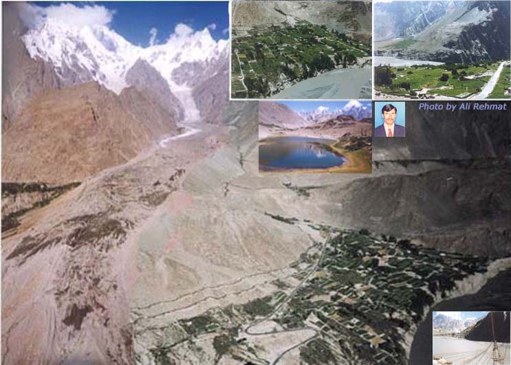
A VIEW OF HUSSAINI VILLAGE, KKH, HUSSAINI GLACIER, BORITH LAKE AND HUNZA RIVER (Photograph by Ali Rehmat) August 2000
My Online Resume
http://giscareers.com/CV-WKLICXP.html
E-mail:
alimusofer@yahoo.com
http://pic5.piczo.com/hussainipk/?preview=y |

