|
INTRODUCTION
The Karakoram region, popularly known as the Northern Areas of Pakistan is an important strategic out post of Pakistan with presence of the soviets, Chines and Indians around, covering about 72,500 square kilometers in the north of Pakistan. The Northern Areas is the home of million people of different ethnic backgrounds, cultures and languages. With some of the highest mountains in the world, it is an alpine region with a wide variety of climatic conditions, resulting in a diversity of plants, animals, and habitats. Two third of its people practice subsistence agriculture, with maize or wheat as the staple crop of the areas depending on the climate. With the construction of the Karakoram Highway in the 1970s, Centuries of isolation came to an end with rapid social and ecological transformation in their wake. The Karakoram Range has an average height of 6000 meters above the sea level. This is also the glaciated area in the world. It contains some of the world's longest glaciers, such as the Siachen glacier. It is said to be the highest battlefield in the world. The other glaciers include Baltoro, Godwin, Austun, Batura, Biafo and Hisper. The Karakoram is extremely inaccessible. Mountain passes situated at various altitudes are only open for five to six months at the year, during the summer. Since, 1954 when the Karakoram Range of Pakistan was opened up to expeditions, for mountaineering and later for tracking, The mountains and glaciers of the North have become international known. The population of the area is small and scattered(888000-1998). The favorite sport in the Northern Area o f Pakistan is Polo. It draws a large number of visitors and participants on the festive occasion of the polo tournament in November every year. Many tourists visit the Northern Areas of Pakistan to view its scenic beauty.
KARAKORAM HIGHWAY
The Karakoram Highway, or KKH, is the greatest wonder of modern Pakistan and one of the most spectacular roads in the world. Connecting Pakistan to China, it twists through three great mountain ranges - the Himalayas, Karakoram and Pamir is the following one of the ancient silk routes along the valleys of the Indus, Gilgit and Hunza rivers to the Chinese border at the Khunzhrav Pass. It then crosses the high Central Asian plateau before winding down through the Pamir to Kashgar, at the western edge of the Taklamakan Desert. By this route, Chinese silks, ceramics, lacquer-work, bronze, iron, fur and spices Traveled west, while the wool, linen, ivory, gold, silver, precious and semi-precious stones, asbestos and glass of South Asia and the west traveled East.
For much of its 1,284 km (905 miles), the Karakoram Highway is overshadowed by towering, barren mountains, a High altitude desert enjoying less than 100 millimeters (four inches) of rain a year. In many of the gorges through which it Passes, it rides a shelf cut into a sheer cliff face as high as 500 meters (1,600 feet) above the river. The KKH has opened up Remote villages where little has changed in hundreds of years, where farmers irrigate tiny terraces to grow small patches of Wheat, barely or maize that stand out like emeralds against the Grey, stony mountains.
The highway is an incredible feat of Engineering and enduring monuments to the 810 Pakistanis and y reckless rate of five centimeters (two inches) a year and the mountains are still growing by about seven millimeters (1/4 of an inch), annually. The KKH runs through the middle of this collision belt, where there is an earth tremor, on average, every three minutes. Karakoram is Turkish for crumbling rock, an apt description for the giant, gray, snow-capped slagheaps that tower above the gorges cut between them. The Indus River flows northwest, dividing the Himalayas from the Karakoram, before being knocked south by the Hindukush. The KKH hugs the banks of the Indus for 310 kilometers of its climb north, winding around the foot of Nanaga Parbat, the ninth highest mountain in the world and the western anchor of the Himalayas. The highway then leaves the Indus for the Gilgit, Hunza and Khunzhrav rivers to take on the Karakoram Range, which boat 12 of the 30 highest mountains in the world. By the time the road reaches the 4,733 meters (15,528-foot). Khunzhrav Pass, it has earned the name of the highest metalled border crossing in the world.
The mountain area of Pakistan is a paradise not only for mountaineers and trakers but also for every- nature lover and particularly for those interested in anthropology and archaeology. The Karakoram highway, an extraordinary accomplishment of ancient dreams may be a wonder of the present age. But to the neighbors of Pakistan and China, the route merely highlights strategic link. However, the highway has heralded a new era for the northern areas of Pakistan. It has opened the door to easier and increasing co-operation between the two countries. The present highway, in fact, began as a pioneering venture of the Pakistan army engineers in 1959 when work started on what was known as the Indus valley road. After the 1965 war with India, Pakistan concluded an agreement to extend the road to the chinse border. In 1967, it was decided to transform the road into an all-weather and dual-carriage highway over the Karakoram, along the ancient Silk Route. After being exposed to untold hardships against the natural barriers and rugged mountain terrain, 10,000 Chines and 15,000 Pakistani engineers and army jawans completed the road in 1969. With certain improvements, the highway was finally inaugurated in June 1978. One could very well imagine the economic cost but the human cost was also staggering, in the process of exploding mountain barriers and constructing 80 bridges almost 300 Pakistani and 160 Chines laid their lives. Many suffered serve injuries. On one occasion, 25 Chines engineers were killed in a landslide near Komila in 1976.
The highway has made it possible to realize the vast scope of expansion in the export of cotton, cotton textiles and other articles to china and the import of Coal, Cement, Iron, Glassware, Cutlery. Chemiclalsand Silk yarns to Pakistan. Indeed, this has accelerated the tempo of trade between the two countries to a level not achieved before in recent history. With modern transport facilities, it is estimated that vehicles carrying goods from Karachi could reach china, s border within 15-20 days. Pakistan could also benefit immensely, if sites along the highway are explored with a view to developing tourists especially from the Western Europe visit the northern areas of Pakistan. The beautiful and scenic ranges of Pamirs, Himalayas, and the Hindu Kush bound this area. From both chines and Pakistan, s perspectives, the road is very important for trade and military matters. In the current strategic jargon, the highway is termed a Chinese window opening towards the southern Asia. For Pakistan, it has been very convenient in shifting light military weapons from china. At present, Although the northern areas of Pakistan are fast changing both economically and socially but their constitutional status with Pakistan remains unchanged, and indeed present a puzzle for most of the people. Such a constitutional crisis does agitate and frustrate the minds of local inhabitants as well. Factually the area is under the bureaucratic control of Azad Kashmir Affairs and Northern Areas, but politically it is deprived of the rights, which Azad Kashmir enjoys.
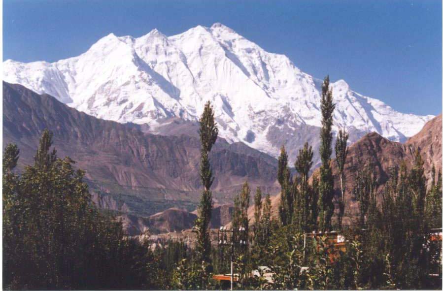
Nanga Parbat (necked Mountain) situated on the western edge of the great Himalayan range is the second highest peak of Pakistan and 3rd in the world. This mountain is 8125 meters (26660) feet high and was originally known as Diamir the abode of god. Many believed that the queen of Siamer lived in a castle of glass stone on the peak and any one who dared to disturb its show on the slopes was finished by fairies living at the top. Nanga Parbet is also known as killer mountain, After repeated attempts and colossal loss of human lives the peak was scaled by the Germans on July 3,1953. Nana Parrot has taken the biggest toll of human lives in the annals of mountaineering, which are nearly 60 by now. Rakaposhi (the goodness of snow) a beautiful and majestic mountain is in Nager valley rising to a height of 7790 maters (25558 feet). Rakaposhi became an object of attraction for mountaineers far as 1892 when Lord Conway visited the area for finding out the possibility of climbing its peak.
Search other sites
http://www.gojal.net
Gojal Hunza
http://pic5.piczo.com/hussainipk/?preview=y
Hussaini Vilage
http://www.alimusofer.multiply.com
Wakhi Songs
www.baturainnpassu.20m.com
http://pic3.piczo.com/xiwoor/?preview=y
www.baturasouth.20m.com
http://www.bbcurdu.com
http://www.shimshal.20m.com
http://www.akdn.org
http://www.hunza.20m.com
http://www.hunza.net
http://www.northernarea.20m.com
|

